- Home
- Government
- Departments
- Planning & Development Services
- Development Permit Applications Open Projects
Development Permit Applications Open Projects
View submissions and provide comments on current development permit applications.
-
-
Unified Land Development Code (ULDC) - Text Amendment
Requested Action - Text Amendment to the Chapter 111, Unified Land Development Code (ULDC) of the Baytown Code of Ordinances to revise Divisions 2.3 and 10.2 of the ULDC regarding Short-Term Rentals (STRs). View Project Details -
Unified Land Development Code (ULDC) - Text Amendment
Requested Action - Text Amendment to the Chapter 111, Unified Land Development Code (ULDC) of the Baytown Code of Ordinances to revise Divisions 2.3 and 10.2 of the ULDC. View Project Details
/CivicAlerts.aspx
-
5111 Ashwood Drive - Special Use Permit
Requested Action - Approval of a Special Use Permit (SUP) to allow for Short-Term Rental in a Suburban Residential (SR) Zoning District. View Project Details -
2015 Massey Tompkins - Special Use Permit & Zoning Map Amendment
Requested Action - Approval of a Special Use Permit (SUP) to allow for the reconstruction of a non-conforming use in a Mixed Residential (MR) Zoning District. View Project Details -
4701 Decker Drive--Special Use Permit--ZP24080057
Requested Action - Special Use Permit (SUP) for the continuation of existing wrecked vehicles processing-related operations in the Light Industrial (LI) Zoning District. View Project Details -
3404 and 3406 Wisconsin Street - Special Use Permit
Requested Action - Approval of a Special Use Permit (SUP) to allow for the reconstruction of a non-conforming use in a Mixed Residential (MR) Zoning District. View Project Details -
1010 Bob Smith Road - Zoning Map Amendment & Special Use Permit
Requested Action(s) - Approval of a Special Use Permit (SUP) to allow the construction and operation of a Battery Energy Storage System (BESS) on the approximately 9-acre subject site located within the Suburban Residential (SR) Zoning District. Read on... -
1500 ML Wismer Rd- Zoning Map Amendment_ZP25070065
Requested Action - Rezone the subject site from Mixed Residential (MR) Zoning District to a General Commercial (GC) Zoning District. View Project Details -
2040 Comprehensive Plan - Future Land Use Plan Amendment
Requested Action(s) - A proposed amendment to the Baytown 2040 Comprehensive Plan’s Future Land Use Plan (FLUP) to amend the map from OR to LSC as it relates to 81+ acres of land along E Wallisville RD. View Project Details -
2040 Comprehensive Plan - Future Land Use Plan Amendment
Requested Action(s) - A proposed amendment to the Baytown 2040 Comprehensive Plan’s Future Land Use Plan (FLUP) to amend the map from OR to LSC as it relates to 81+ acres of land along E Wallisville RD. View Project Details -
1500 ML Wismer Rd- Zoning Map Amendment_ZP25070065
Requested Action - Rezone the subject site from Mixed Residential (MR) Zoning District to a General Commercial (GC) Zoning District. View Project Details -
3402 Shady Hill Drive--Special Use Permit--ZP25060050
Requested Action - Special Use Permit (SUP) for the establishment of a recreational vehicle (RV) park with 77 spaces in the General Commercial (GC) Zoning District. View Project Details -
3402 Shady Hill Drive--Special Use Permit--ZP25060050
Requested Action - Special Use Permit (SUP) for the establishment of a recreational vehicle (RV) park with 77 spaces in the General Commercial (GC) Zoning District. View Project Details -
4623 Barkuloo Road - Zoning Map Amendment_ZP25050039
Requested Action - Rezone the subject site from Open Space/Recreation (OR) Zoning District to a Mixed Residential (MR) Zoning District. View Project Details -
Arcanum Nest- Zoning Map Amendment_ZP25050041
Requested Action - Rezone the subject site from General Commercial (GC) Zoning District to a Heavy Industrial (HI) Zoning District. View Project Details -
Lake Ridge Subdivision Sections 5 & 6 - Subdivision Variance_ZS25030023
Requested Action - A subdivision variance requesting allowance for a single external access point for a proposed 63-lots residential subdivision located in the City's Extraterritorial Jurisdiction (E.T.J). Read on... -
Unified Land Development Code (ULDC) - Text Amendment
Requested Action - Text Amendment to the Chapter 111, Unified Land Development Code (ULDC) of the Baytown Code of Ordinances to revise Divisions 2.1, 2.2, 2.3, 3.3, 3.4 and 3.6 of the ULDC. View Project Details -
2211 Connally Road - Zoning Map Amendment_ZP25020011
Requested Action - Rezone the subject site from Suburban Residential (SR) Zoning District to a General Commercial (GC) Zoning District. View Project Details -
8808 Needlepoint Road--Special Use Permit--ZP24120090
Requested Action - Special Use Permit (SUP) for the construction of a 190-foot tall monopole telecommunication tower and associated facilities in the General Commercial (GC) Zoning District View Project Details -
1112 Kilgore Rd - Special Use Permit (ZP24100070)
Requested Action - Special Use Permit to permit the construction of a residential accessory use (a carport) prior to the construction of a principal use. View Project Details -
2204 Maryland Avenue - Subdivision Variance_ZS25010001
Requested Action - A variance requesting allowance for a lot with reduced minimum lot size from 5,000 square feet to 2,570 square feet in the Mixed Residential (MR) Zone. Read on... -
6835 Aspen Peak Drive - Zoning Variance_ZP24110078
Requested Action - A variance requesting the placement of an above-ground swimming pool in the street side yard and to reduce the street side setback for the pool from 15 feet to 8.7 feet. View Project Details -
5814 N SH 146 - Zoning Map Amendment (ZP24100069)
Requested Action - Rezone the subject property from Planned Unit Development (PUD) to Mixed Residential (MR). View Project Details -
1000 N Alexander Drive - Zoning Map Amendment
Requested Action - Rezone the subject property from Mixed-Use Neighborhood (MUN) to a Neighborhood Commercial (NC) Zoning District. View Project Details -
2109 W Texas Avenue - Zoning Map Amendment (ZP24110079 )
Requested Action - Rezone the subject property from General Commercial (GC) to Mixed Residential (MR). View Project Details -
1112 Kilgore Rd - Special Use Permit (ZP24100070)
Requested Action - Special Use Permit to permit the construction of a residential accessory structure (a carport) prior to the construction of a primary structure. View Project Details -
4906 Garth Road - Zoning Variance
Requested Action - Increase Lot coverage on the property. View Project Details -
600 & 620 Ward Road - Zoning Map Amendment
Requested Action - Rezone the subject property from Mixed Residential at Low to Medium Densities (SF2) or Mixed Residential (“MR” in the new Code) to Neighborhood Serving Commercial (NSC) or Neighborhood Commercial (“NC” in the new Code). View Project Details -
907 Bob Smith Road - Special Use Permit
Requested Action - A Special Use Permit to allow for the reconstruction of single-family residential unit as a continual nonconforming use in the General Commercial (GC) Zone. View Project Details -
2504 Massey Tompkins Road - Subdivision Variance
Requested Action - A subdivision variance to allow no lot frontage on an improved public right-of-way. View Project Details -
2935 Railwood Street - Subdivision Variance
Requested Action - A subdivision variance to allow no lot frontage on an improved public right-of-way. View Project Details -
2700 N. Main Street - Zoning Map Amendment
Requested Action - To rezone the subject property from Mixed Residential at Low to Medium Densities (SF2) to General Commercial (GC). View Project Details -
1710 N. Main Street - Special Exception
Requested Action - A Special Exception from the minimum 10 feet transition buffer to adjacent land uses. View Project Details -
3306 Fox Drive - Subdivision Variance
Requested Action - A subdivision variance to allow reduced lot frontage on an improved public right-of-way. View Project Details -
Cedar Bayou Road - Zoning Map Amendment (ZP 23110083)
Requested Action - To rezone approximately 7.19 acres, from Single-family estate (SFE) to Mixed residential at low to medium densities (SF2). View Project Details -
City Sponsored Rezoning - Massey Tompkins
Requested Action - The goal of the City Sponsored Rezoning is to provide flexibility to property owners to expand existing commercial uses or develop new commercial uses without the need for extra layers of compliance such as (SUP, Rezone etc.) View Project Details -
Satsangdiksha LLC Addition - Subdivision Variance
Requested Action - A subdivision variance from the Unified Land Development Code (ULDC), Sec. 4.17(1), which requires frontage on an improved public right-of-way. View Project Details -
1332 Battlebell Road - Subdivision Variance
Requested Action - A subdivision variance from the Unified Land Development Code (ULDC), Sec.4.105(1), which requires a minimum 50-foot lot frontage on an improved public right-of-way. View Project Details -
4208 Crosby Cedar Bayou Road - Zoning Map Amendment
Requested Action - A Zoning Map Amendment to the official zoning map to rezone approximately 2.96 acres, from Open Space/Recreation (OR) to Mixed Residential at Low to Medium Density (SF2). View Project Details -
7128 E. IH 10 - Special Use Permit
Requested Action - A special use permit (SUP) for an amendment to an approved SUP for warehouse development within GC zoning district. View Project Details -
3603 Danek Road - Subdivision Variance
Requested Action - A subdivision variance from the Unified Land Development Code (ULDC), Sec.4.105(1), which requires a minimum 50-foot lot frontage on an improved public right-of-way. View Project Details -
1001 E IH 10 - Voluntary Annexation & Zoning Map Amendment
Requested Action - 1) Voluntary Annexation of approximately 0.97 acres 2) Zoning Map Amendment to the official zoning map to rezone an approximately 0.97 acres portion of the subject property from Open space/Recreation (OR) & General Commercial (GC). View Project Details -
Special Use Permit - Garth Road Battery Energy Storage System (BESS)
Requested Action - A Special Use Permit to allow for a Battery Energy Storage System (BESS) within the General Commercial (GC) Zoning District. View Project Details -
7128 E. IH 10 - Zoning Map Amendment and Special Use Permit
Requested Action - To rezone the subject property, approximately 46.4 acres, from Open Space/Recreation (OR) to General Commercial (GC); and a request for a special use permit to allow a warehouse development within GC zoning district. View Project Details -
Special Use Permit - Crematorium at 2850 Ferry Road
Requested Action - A Special Use Permit (SUP) to allow for the funeral home/crematorium land use within the General Commercial (GC) Zoning District. View Project Details -
ULDC Text Amendment - Temporary Signs
Requested Action - A proposed text amendment to Appendix A - Unified Land Development Code (ULDC) to change Section 5.79 New Signs, concerning certain language addressing all temporary off-premises signs. View Project Details -
9 Northridge Drive - Zoning Map Amendment
Requested Action - A Zoning Map Amendment to the official zoning map to rezone approximately 0.41 acres of land located at 9 Northridge Drive from General Commercial (GC) to Mixed Residential at Low to Medium Densities (SF2). View Project Details -
609 E. Adoue Avenue - Zoning Variance
Requested Action - A variance from the Unified Land Development Code, Article III. Division 1. Table 3-1. Property Development Standards, to reduce the required 15 feet minimum street side setback to 6.8 feet. View Project Details -
120 Bowie Street - Zoning Variance
Requested Action - A variance from the Unified Land Development Code, Article III. Division 1. Table 3-1. Property Development Standards, requesting a variance to the required minimum rear yard setback on the property. View Project Details -
ULDC Interpretation Appeal
Requested Action - An appeal of the Planning and Development Services Director’s interpretation of the Unified Land Development Code’s (ULDC) definition of the land use, “Parking, Commercial.” View Project Details -
ULDC Text Amendment - I-PUD
Requested Action - A proposed text amendment to Appendix A - Unified Land Development Code (ULDC). View Project Details -
406 E. Hunnicutt Avenue - Zoning Variance
Requested Action - A variance from the Unified Land Development Code, Article III. Division 1. Table 3-1. Property Development Standards, requesting a variance to the required minimum front yard setback on the property. View Project Details -
3715 E IH 10 - Special Use Permit
Requested Action - A Special Use Permit (SUP) to allow for the warehousing land use within the General Commercial (GC) Zoning District. View Project Details -
City Sponsored Rezoning - Blue Heron Parkway Corridor
Requested Action - The goal of the City Sponsored Rezoning is to provide flexibility to property owners to expand existing commercial uses or develop new commercial uses without the need for extra layers of compliance such as (SUP, Rezone etc.) View Project Details -
2000 New Jersey Street - Zoning Variance
Requested Action - A variance from from the Unified Land Development Code, Article III. Division 1. Table 3-1. Property Development Standards, requesting a variance to the required minimum street side setback on the property. View Project Details -
John Martin Right-of-Way - Annexation
Requested Action - Annexation being the entire width of John Martin Road right-of-way beginning 3,508.89 feet south of IH-10 (edge of current city limits) and extending south approximately 4,235.55 feet to the West Cedar Bayou Lynchburg Road right-of-way. View Project Details -
1400 Blue Heron Parkway - Voluntary Annexation
Requested Action - Voluntary annexation of privately-owned land consisting of one (1) tract situated in the D McFadden Survey, Abstract 591, generally located along Blue Heron Parkway between Barkuloo Road and Crosby Cedar Bayou Road. View Project Details -
5225 Middleton Street - Zoning Map Amendment
Requested Action - A Zoning Map Amendment to the official zoning map to rezone approximately 2.47 acres of land located at 5225 Middleton Street from General Commercial (GC) to Mixed Residential at Low to Medium Densities (SF2) Zoning District. View Project Details -
117 North Holly Drive - Zoning Variance
Requested Action - A variance from the Unified Land Development Code, Article III. Division 1. Table 3-1. Property Development Standards, requesting a variance from the required minimum front yard setback to a carport on the property. View Project Details -
24 Ashleyville Road - Zoning Map Amendment
Requested Action - A Zoning Map Amendment to the official zoning map to rezone approximately 3.02 acres of land located at 24 Ashleyville Road, from General Commercial (GC) to Medium Density Mixed Residential (MF1) Zoning District. View Project Details -
7300 East IH 10 - Special Exception
Requested Action - A special exception from the Unified Land Development Code, Land use Conditions, to reduce the required setback of 100 feet to adjacent property to the east, and reduce the open space/vegetative buffer width on both sides of property. View Project Details -
6455 E IH 10 - Zoning Map Amendment
Requested Action - A Zoning Map Amendment to the official zoning map to rezone approximately 40 acres of land located at 6455 E IH 10 from Open Space/Recreation (OR) to a General Commercial (GC) Zoning District. View Project Details -
706 E. Cedar Bayou Lynchburg Road - Zoning Map Amendment
Requested Action - A Zoning Map Amendment to the official zoning map to rezone approximately 2.2 acres of land located at 706 E. Cedar Bayou Lynchburg Road from Open Space/Recreation (OR) to Neighborhood Serving Commercial (NSC) Zoning District. View Project Details -
703 Hunt Road - Zoning Map Amendment
Requested Action - A Zoning Map Amendment to the official zoning map to rezone approximately 35.1 acres from General Commercial (GC) to Medium Density Mixed Residential (MF1) Zoning District. View Project Details -
5814 N SH 146 - Voluntary Annexation, Zoning Map Amendment, and Industrial Planned Unit Development
Requested Action - Voluntary Annexation of 53.67 acres, Zoning Map Amendment to rezone an approximately 49.87 acres of the subject property and an Industrial Planned Unit Development for the rezoned 49.87 acres of the subject property referrenced above. View Project Details -
2711 North Main Street - Special Exception
Requested Action - A special exception to allow a warehouse use in a GC zoning district to reduce the building setback from 100 feet to 25 feet and the vegetative buffer from 50 feet to 25 feet View Project Details -
2111 Ontario Avenue- Zoning Variance and a Special Exception
Requested Action - A variance from the Unified Land Development Code, Property Development Standards to reduce minimum setback and a special exception from the Unified Land Development Code to reduce the required front setback to attached garages. View Project Details -
315, 319 and 325 E Defee Ave. - Zoning Map Amendment
Requested Action - Zoning Map Amendment to the official zoning map to rezone approximately 0.33 acres of land located at 315, 319 and 325 E Defee Ave from Mixed Residential at Low to Medium Densities to Neighborhood Serving Commercial Zoning District. View Project Details -
8419 Silver Streak Drive - Zoning Variance
Requested Action - A variance from the Unified Land Development Code, Article III. Division 1. Table 3-1. Property Development Standards requesting a variance from the required minimum interior side setback for the property. View Project Details -
5627 Barkuloo Road - Zoning Map Amendment
Requested Action - Zoning Map Amendment to the official zoning map to rezone approximately 13.26 acres from Open Space/Recreation (OR) to Low Density Single-Family Residential (SF1) Zoning District. View Project Details -
Bay Creek 2.0 Voluntary Annexation and Zoning Map Amendment
Requested Action - 1) Voluntary Annexation of the subject property and 2) Zoning Map Amendment to the official zoning map to rezone approximately 55.491 acres from Open space/recreation to Mixed Residential at low to medium densities Zoning District. View Project Details -
3404 Wisconsin Street - Special Use Permit
Requested Action - A Special Use Permit for the reconstruction of a non-conforming use located at 3404 and 3406 Wisconsin Street. View Project Details -
715 Alamo Street - Zoning Map Amendment
Requested Action - Zoning Map Amendment to the official zoning map to rezone approximately 5.26 acres of land located at 715 Alamo Street from General Commercial (GC) to Mixed Residential at Low to Medium Densities (SF2) zoning district. View Project Details -
417 West Main Street- Special Exception
Requested Action - A variance from the Unified Land Development Code, Article II, Division 3, Section 2.10 Land use Conditions, condition A44, to reduce the open space setback from any adjacent non-residential uses from 20 feet to 11 feet. View Project Details -
2111 Ontario Ave. Zoning Map Amendment
Requested Action - Zoning Map Amendment to the official zoning map to rezone approximately 0.079 acres from General Commercial (GC) to Mixed Residential at Low to Medium Densities (SF2) Zoning District. View Project Details -
2015 Massey Tompkins Road Zoning Map Amendment
Requested Action - Zoning Map Amendment to the official zoning map to rezone approximately 29.26 acres from Open Space/Recreation (OR) to Mixed Residential at Low to Medium Densities (SF2) and General Commercial (GC) zoning district. View Project Details -
2210 E IH 10 Voluntary Annexation and Zoning Map Amendment
Requested Action - 1) Voluntary Annexation of the subject property and 2) Zoning Map Amendment to the official zoning map to rezone approximately 18.95 acres from Open space/recreation (OR) to Light Industrial (LI) zoning district. View Project Details -
2518 Massey Tompkins Road - Zoning Map Amendment
Requested Action - Zoning Map Amendment to the official zoning map to rezone approximately 2 acres from Low Density Single-family Residential Dwellings (SF1) to General Commercial (GC) Zoning Districts. View Project Details -
San Jacinto Blvd and Santavy St - Planned Unit Development (San Jacinto Cottages)
Requested Action - A Planned Unit Development to support the development of a 13.51 acre multi-family cottage development. View Project Details -
306 East Gulf Avenue - Zoning Variance (DENIED)
Requested Action - A variance from the Unified Land Development Code. Property Development Standards to reduce the minimum lot size from 4,840 square feet to 3,750 square feet and reduce the minimum lot frontage from 50 feet to 37.50 feet. View Project Details -
North Main Street & Hunt Road - Zoning Map Amendment
Requested Action - Amendment to the official zoning map to rezone approximately 57 acres of an approximately 64 acre parcel from Single-family estate and General commercial (GC) to a Mixed residential at low to medium densities (SF2) zoning district. View Project Details -
3715 E IH 10 Voluntary Annexation and Zoning Map Amendment
Requested Action - 1) Voluntary Annexation of the subject property; 2) Zoning Map Amendment to the official zoning map to rezone approximately 196.5 acres from Open space/recreation (OR) to General Commercial (GC) zoning district. View Project Details -
Limited Purpose Annexation - Baytown Crossings
Requested Action - A Limited Purpose Annexation (LPA), which differs from a Full Purpose annexation in several ways. View Project Details -
9300 Needlepoint Road - Special Use Permit
Requested Action - A special use permit application to allow for the construction of rail lines on the subject tract to serve the existing Raven Butene-1 facility immediately north of the subject tract. View Project Details -
Sjolander and I-10 Annexation and Zoning Map Amendment
Requested Action - 1) Voluntary Annexation of the subject property at the southeast intersection of Sjolander and I-10. 2) Zoning Map Amendment to the official zoning map to rezone from an Open Space/Recreation to a Light Industrial (LI) zoning district. View Project Details -
1401 Blue Heron Parkway - Zoning Map Amendment
Requested Action - Zoning Map Amendment to the official zoning map to rezone approximately 13.32 acres from Open space/recreation (OR) to Medium density mixed residential (MF1) zoning district. View Project Details -
1901 Ellis School Road (IDV) Voluntary Annexation and Zoning Map Amendment
Requested Action - 1) Voluntary Annexation of the subject property and adjacent Thompson Road right-of-way 2) Zoning Map Amendment to the official zoning map to rezone from Open space/recreation to General Commercial zoning district. View Project Details -
7300 East Freeway (Interstate 10) - Zoning Map Amendment
Requested Action - Zoning Map Amendment to the official zoning map to rezone approximately 3.0 acres from Open Space/Recreation (OR) to General Commercial (GC) Zoning District. View Project Details -
8902 N Main ST - Zoning Map Amendment
Requested Action - Zoning Map Amendment to rezone approximately 69.50 acres from Open space/recreation ("OR") to Mixed residential at low to medium densities ("SF2") zoning district View Project Details -
Cedar Bayou Road- Zoning Map Amendment (DENIED)
Zoning Map Amendment to the official zoning map to rezone approximately 4.5 acres from Neighborhood Serving Commercial (NSC) to Medium Density Mixed Residential (MF1) Zoning District. View Project Details
/CivicAlerts.aspx
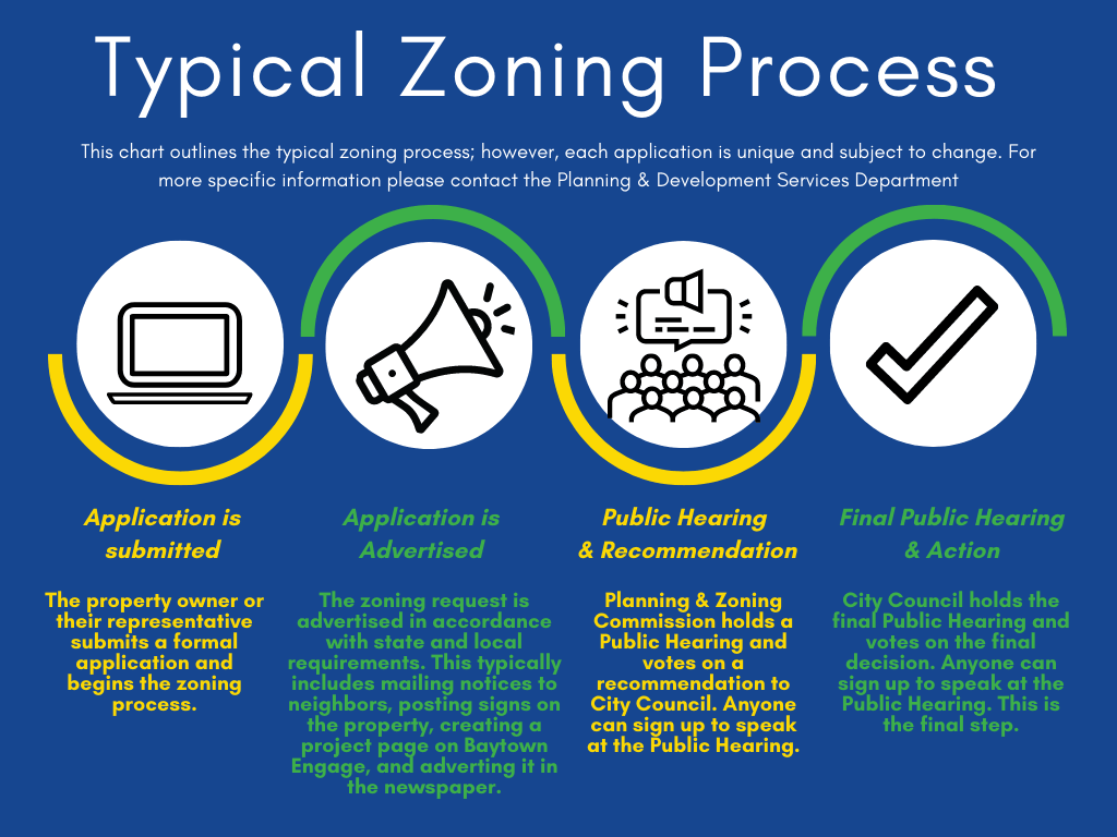 Typical Zoning Process
Application is submitted
The property owner or their representative submits a formal application and begins the zoning process.
Application is advertised
The zoning request is advertised in accordance with state and local requirements. This typically includes mailing notices to neighbors, posting signs on the property, creating a project Newsflash on the City's website and advertising it in the newspaper.
Public Hearing and Recommendation
Planning and Zoning Commission holds a Public Hearing and votes on a recommendation to City Council. Anyone can sign up to speak at the Public Hearing.
Final Public Hearing & Action
City Council holds the final Public Hearing and votes the final decision. Anyone can sign up to speak at the Public Hearing. This is the final step.
City Sponsored Zoning Process
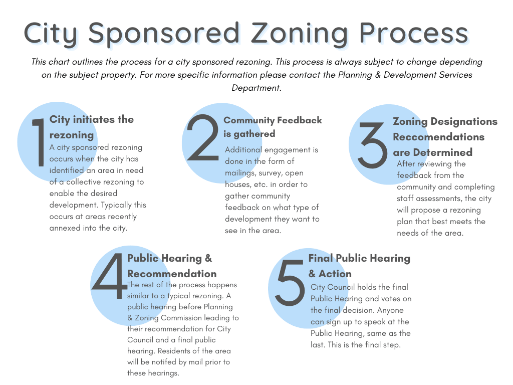 City Initiates the Rezoning
A city sponsored rezoning occurs when the city has identified an area in need of a collective rezoning to enable the desired development. Typically this occurs at areas recently annexted into the city.
Community Feedback is Gathered
Additional engagement is done in the form of mailings, survey, open houses etc. in order to gather community feedback on what type of development they want to see in the area.
Zoning Designations Recommendations are Determined
After reviewing the feedback from the community and completing staff assessments, the city will propose a rezoning plan that best meets the needs of the area.
Public Hearing and Recommendation
The rest of the proces shappens similar to a typical rezoning. A public hearing before Planning and Zoning Commission leading to their recommendation for City Council and final public hearing. Residents of the area will be notified by mail prior to these hearings.
Final Public Hearing and Action
City Council holds the final Public Hearing and votes on the final decision. Anyone can sign up to speak at the Public Hearing, same as the last. This is the final step.